Bab adh-Dhra`
Final reports for Lapp’s excavation of the cemetery at Bab edh-Dhra’ (Schaub and Rast 1989), and for the EDSP’s excavations of the town site (Rast and Schaub 2003) have been published by Eisenbrauns. Please see the EDSP bibliography for the citations. The following provides a summary of the results, and was originally published in The New Encyclopedia of Archaeological Excavations in the Holy Land (published by IES in 1993). Final results from the townsite excavations have been published in the 2003 volume, and the finalized bioanthropological analysis from the Smithsonian excavations have been published (Ortner and Fröhlich 2008). Archaeological analysis of the cemetery is ongoing and will be published after the Numeira volume appears.
LOCATION
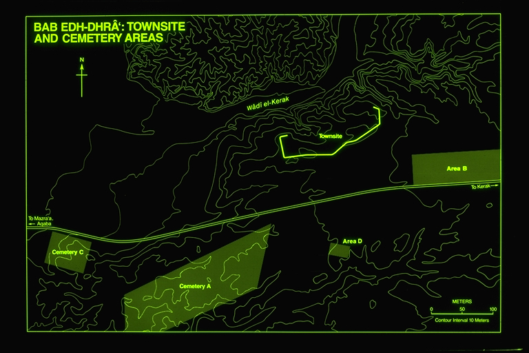
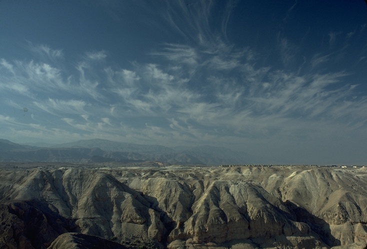
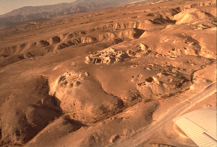
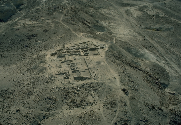
Bab edh-Dhra’ is located on the Jordanian side of the Dead Sea east of the Ghor el Mazra’a and the Lisan peninsula at the southeast end of the Dead Sea. It is situated at an elevation approximately -240 m. below sea level. The site includes a walled town located on the south bank of Wadi Kerak, extra-mural occupation in the Sahl edh-Dhra to the south and east, and a large cemetery 500 m. southwest of the town (Fig. 1). The asphalt road from Kerak to Mazra’a and Safi passes between the town and the cemetery. A modern settlement of 400 town houses south of the cemetery has been built for employees of the Arab Potash Company.
IDENTIFICATION
The site of Bab edh-Dhra’ has been discussed in connection with the “cities of the plain” (Gen. 13:10-13; 14;18-19) because of the traditional view that these cities were located at the south end of the Dead Sea. Albright (1926) conjectured that Bab edh-Dhra’ was a ceremonial site for these cities and that the ruins of the cities were probably located under the shallow waters of the southern basin of the Dead Sea. Lapp (1968a) interpreted Bab edh-Dhra’ as a cultic burial ground for the cities. The discovery of four other sites with Early Bronze cultural materials during a survey of the southern Ghor region in 1973 led Rast and Schaub (1974) to suggest a possible linkage to the biblical cities. Van Hattem (1981) carried this suggestion further by identifying Bab edh-Dhra’ as Sodom. In a recent article which analyzes the tradition of Sodom Rast has revised the suggestion that all the Ghor sites were historically linked with the cities of the plain, arguing that the biblical tradition centered originally on a pair of cities, Sodom and Gomorrah. The two related Early Bronze towns of Bab edh-Dhra’ and Numeria may thus have generated the popular biblical tradition (Rast 1984).
EXPLORATIONS
Although extensive ruins in the Sahl edh-Dhra’ were noted by various explorers of the 19th century such as de Saulcy, Irby and Mangles, and Lynch, the walled town area was not discovered until A. Mallon noted it during the 1924 survey of the Ghor by the American Schools of Oriental Research and the Pitsburgh-Xenia Seminary under the direction of W.F. Albright and M.G. Kyle. Published reports on the survey (Albright 1924,1926; Mallon 1924) included descriptions of what was termed an enclosure, several structures outside the latter, a series of supposed cairn tombs scattered over the plain, and seven fallen monoliths east of the town.
In 1964 further attention was drawn to the site when it was realized that pottery which had glutted the antiquities markets since 1958 had its origin in the cemetery area of Bab edh-Dhra’. A sampling of this pottery was published by Saller (1964-65).
In addition to the 1973 Rast-Schaub survey mentioned above there have been more recent explorations which have explored the Sahl edh-Dhra’ region. The area just south of the Bab edh-Dhra’ cemetery was surveyed in 1977, before the construction of the modern township site, by David McCreery and Vincent Clark. McCreery published a report on the overall results of this survey (1977-78) and Clark in a later article discussed the Chalcolithic tumuli (1982). Further to the east, on the banks of the Wadi edh-Dhra’, a sounding in a Neolithic site was made by Crystal Bennett (1980). Extensive surveys of the region have also been conducted in connection with the 1975-81 excavations.
HISTORY OF EXCAVATIONS
Lapp Campaigns
The rediscovery of the site’s importance in 1964 prompted a series of three excavations, two in 1965 and one in 1967, sponsored by the American Schools of Oriental Research and directed by the late Paul W. Lapp. Two field seasons, in March-April of 1965 and in February of 1967, focused on various cemetery areas. The majority of the tombs and funerary buildings examined were located in Cemetery A. Cemetery B included a series of “tholoi” located on an east-west line along the modern road. Several tombs and a funerary building were excavated in Cemetery C which was situated on the western slopes of the cemetery area as it descends into the Ghor. Cemetery D contained only one tomb aprroximately 500 m. to the east of Cemetery A (Lapp 1966, 1968b; Schaub and Rast 1989).
Soundings in the settlement area were conducted during the second field season, in the fall of 1965 (Lapp 1966b). Seven fields were opened up but four of these were very limited. The major fields (I and II on the east and IV on the west) were plotted in relation to the defense system of the settlement. A major stone wall dating to EB III was uncovered at the east and west ends of the town site. On the east end an earlier mudbrick wall was exposed under the stone wall. The small probes within the settlement (Fields III,V,VI and VII) yielded only limited occupational data, but on the basis of debris indicating settlement and the defensive walls Lapp concluded that the site represented the ruins of a town rather than a religious enclosure as proposed by Albright.
In addition to the preliminary reports on the three seasons Lapp published two papers interpreting the overall significance of the finds at Bab edh-Dhra’. One study linked the cemetery at Bab edh-Dhra’ to the cities of the plain as a possible ceremonial burial ground for these cities. (Lapp 1968a) A second traced the origins of the early EB settlers of the area to southern Russia and connected their migration to Bab edh-Dhra’ with the Kurgan movement theories of M. Gimbutas (Lapp 1968c).
Expedition to the Dead Sea Plain (EDSP)
After Lapp’s untimely death in l970 W.E Rast and R.T. Schaub, both staff members of the l967 expedition, took over the reponsibility of publishing the final reports of the excavations. Their research on Bab edh-Dhra’ prompted a new survey of the southern Ghor in 1973. The discovery of four additional Early Bronze sites (Numeira, Safi, Feifeh and Khanazir) by the survey led to the organization of a new expedition co-directed by Rast and Schaub and devoted to exploring the interrelation of these sites.
The Expedition to the Dead Sea Plain Sea is affiliated with the American Schools of Oriental Research and has been funded by grants from the National Endowment for the Humanities, the National Geographic Society, and by contributions from several corporations and foundations as well as a group of individuals. Several institutions,including Valparaiso U., Indiana U. of Pennsylvania, St.John’s U., in Collegeville, Kansas State U., the U. of Montana, Harvard Semitic Museum , U. of Pittsburgh, and Carnegie Museum of Pittsburgh have contributed staff and financial support. The Bab edh-Dhra’ cemetery project is sponsored jointly by ASOR and the Smithsonian Institution, with Donald Ortner as coordinator. Four field seasons at Bab edh-Dhra’ (1975, 1977, 1979 and 1981) and Numeira (1977,1979,1981 and 1983) have completed the first phase of the expedition. A second phase, concentrating on the sites of Feifeh and Khanazir, began in 1989. Michael Coogan of Harvard U. has been the field director of the Numeira excavations since l979.
The expedition is problem-oriented and has as its principal objective a multidisciplinary investigation of the southeastern Dead Sea plain. Problems addressed by the expedition staff include the following: changing settlement patterns; agricultural practices and technologies; sizes and interrelationships of the population groups of the sites during the several phases; diet and disease factors among the populations; evidence for trade contacts; and a variety of environmental problems focused on natural resources, land forms and climate. Although the present report concentrates on the archaeological results, some of the results of the environmental investigations are also incorporated.
Complete preliminary reports have been published for each of the four field seasons (Rast and Schaub 1978, 1980, 1981, 1983).
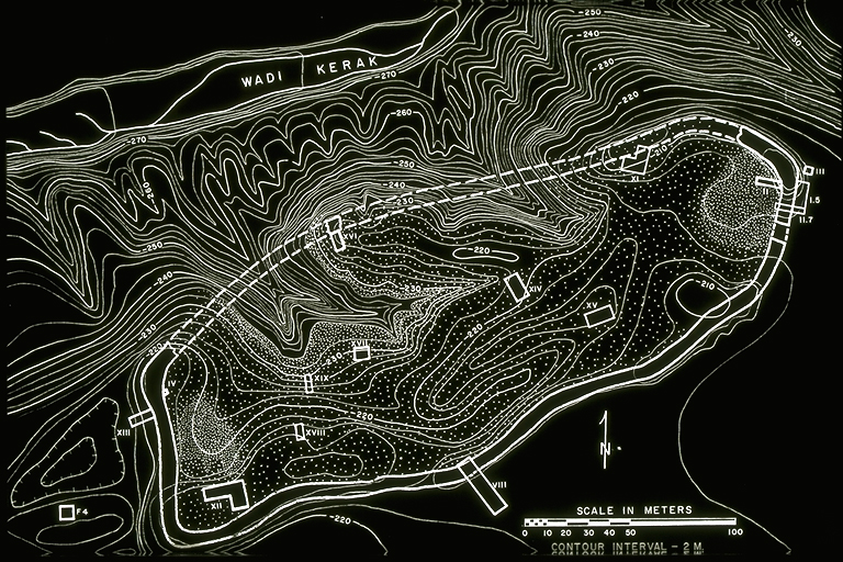
The numbering system of Lapp has been continued by the EDSP. In the town site thirteen new fields have been investigated. Two were located along the defenses, Field VIII on the south wall line and Field XIII on the exterior side of the western wall. The earlier Field IV on the interior of the west wall was also expanded. Four fields were plotted on the highest areas within the town : Field XI in the northeast, Field XII and XVIII in the southwest and Field XVI along the northern ridge. The interior slopes of the town were examined in Fields XIV, XV, XVII and XIX. Excavation in Field IX to the south of the town site and Field X to the northeast focused on extra-mural occupation. Area F,which contained tombs and occupation, was situated west of the defensive line.
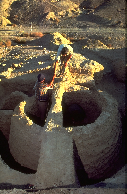
A total of thirty three shaft tombs and four funerary buildings dating to the Early Bronze Age have been excavated during the four seasons of the expedition, most of which are located in Cemetery A. Among the tombs from other areas one was excavated in Cemetery B, three in Cemetery C and one in Cemetery D. New areas of the cemetery which were explored were Cemetery E, located between Cemeteries A and D, with a single surface burial, Area F ,west of the town, with four tombs, and Cemetery G, located between Cemeteries A and C, with six tombs excavated. Two occupation areas were also discovered on the edge of the cemetery ,designated Areas H and J.
During the 1981 field season Bruno Frohlich of the Smithsonian Institution completed a comprehensive topographical survey of the cemetery area using electronic survey equipment to determine the extent of the cemetery and the location and density of unidentified shaft tombs and funerary buildings (Frohlich and Ortner,1982).
Geology
The town site is situated on an alluvial fan surface consisting of sediments washed out from the Wadi Kerak. A major border fault lies just to the east of the site extending to the north along the shore of the Dead Sea. Geological investigation has concluded that during the Early Bronze Age the floor of the Wadi Kerak was at least 20 m. above its present level. Post-occupation downcutting of the wadi has caused dramatic topographic change within the town. Two major tributary wadis removed large areas of the occupational levels in the center of the town. The upper levels of the natural stratigraphy, on which the town was built, include pre-Lisan gravel and sand, Lisan Marl, and in some of the higher areas, a fine-grained, cross-bedded sand with gravel interbeds at the top of the Lisan Marl (Donahue 1980).
Paleolithic. The earliest evidence of human utilization of the Bab edh-Dhra’ area was discovered during the 1977 expedition’s survey near the mouth of the Wadi Kerak. Most of the light scatter of material appeared to date to the Middle Paleolithic although there were representative Lower Paleolithic tools limited to solitary discards or found in secondary deposition (McConaughy 1981).
Neolithic. Pre-Pottery Neolithic is represented at a site at the eastern edge of the Sahl edh-Dhra’, about 5 km. east of Bab edh-Dhra’.. A series of occupation levels was exposed in the sides of a trench cut on the west bank of the Wadi edh-Dhra’ near a spring which today is the most abundant source of water in the edh-Dhra’ area (Bennett,1980).
Chalcolithic. Chalcolithic remains were reported from the 1977 survey of the Potash township site. Among the structures dated to the Chalcolithic period were several circular stone masses below which were meager human remains indicating burials. Nearby were also fragmentary stone foundations of a building. Most of the Chalcolithic material appeared to be concentrated in the northwest area of the township site just south of the Bab edh-Dhra’ Early Bronze age cemetery (McCreery 1977-78; Clark 1982).
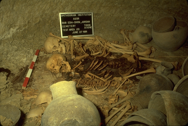
Early Bronze IA. For the Early Bronze period the EDSP has continued to use the terminology set forth by Lapp (1968b) with EB IA denoting the earliest and EB IV the latest phases represented. The data for EB IA came predominantly from shaft tomb burials. The Lapp excavations cleared twenty seven shaft tombs with forty seven chambers in cemetery A containing pottery of EB IA type. Six additional tombs with single chambers were located on the slopes of cemetery C. The EDSP has excavated thirty EB IA shaft tombs with seventy three chambers in areas A, C, F, and G.
The majority of shafts of the early phase are circular or elliptical in plan. Exceptions were three examples with rectangular shafts which were located in the same area of the cemetery. Chambers cut from the shaft varied from one to five. Of the forty eight shafts excavated in the A cemetery, twenty two had a single chamber, eight had two chambers and eighteen had three to five chambers. The chambers varied in shape from circular to square, with flat, slightly rounded, or domed roofs and with a diameter between 1.47 m. and 2.50 m and a height between .75 and 1.25 m.
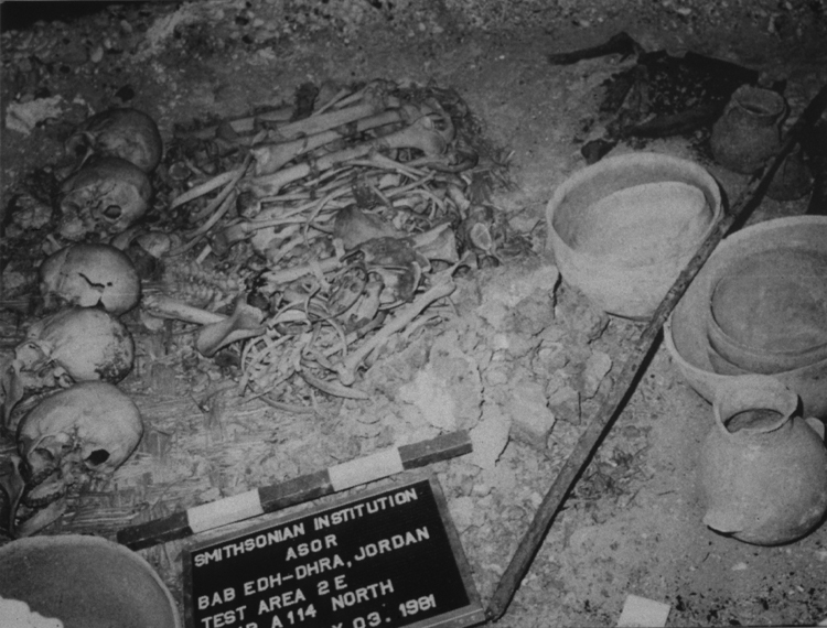
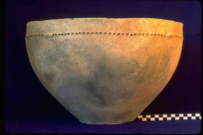
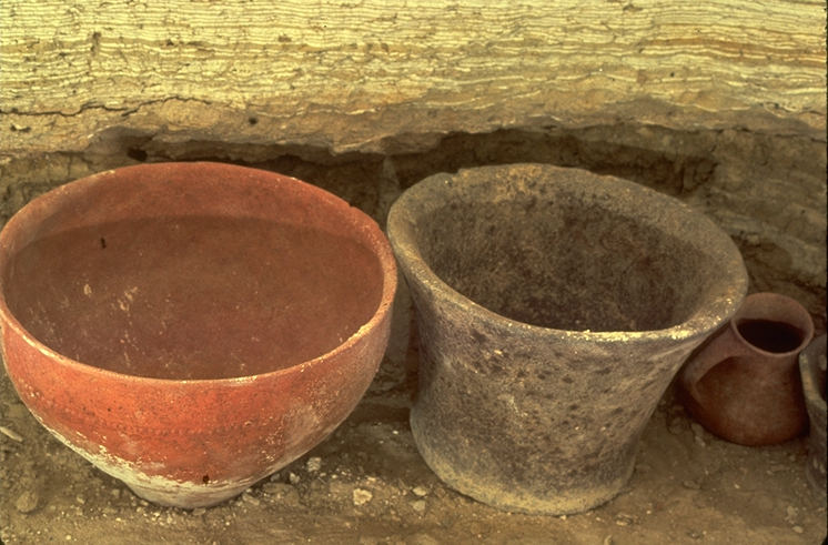
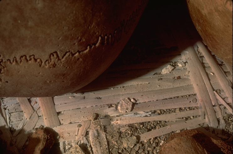
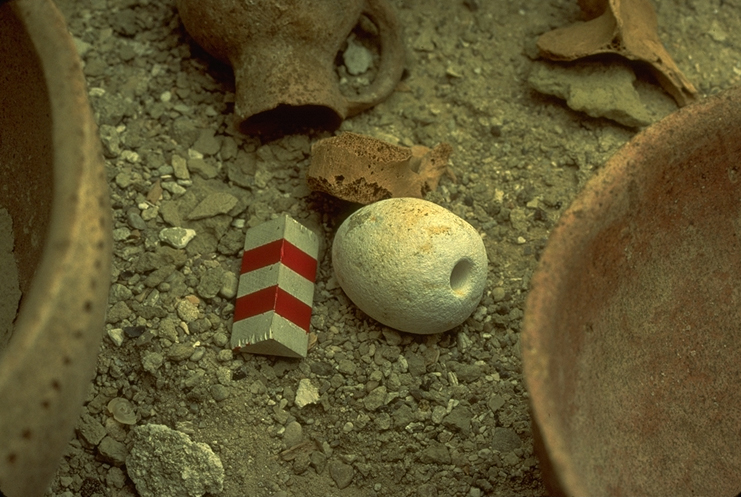
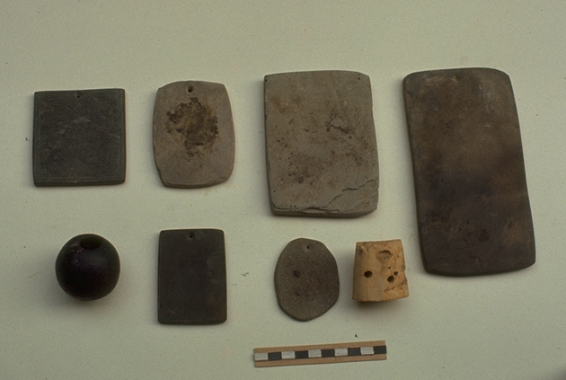
Within the chambers burials consisted of a central disarticulated bone pile with skulls arranged in a line to the left of the bone group as seen from the doorway. Traces of matting were frequently found under the bone groups. Among tomb objects hand-made ceramic vessels dominated. The most frequent shapes were wide deep bowls, small deep bowls, large ledge-handled jars, medium-sized loop-handled jars and loop-handled juglets. All of these basic shapes occur in both fine and plain wares. The majority of vessels were made of fine ware with thin walls and a reddish-orange slip which is frequently burnished. Decoration, which occurs mostly on bowls and jars, was either punctate or a raised, slashed band. The plain ware pots had thick walls and were rough in surface finish with infrequent slip. Punctate decoration, generally more crude in technique, is also found on these vessels. A few of the forms have close parallels in the Jericho Proto Urban A tombs but similar groups, especially with the distinctive ware and decoration, are not yet known outside of the Bab edh-Dhra’area. Other objects included stone maceheads, shell bracelets, stone jars, beads, unfired clay figurines, and on rare occasions cloth and wooden objects.
The only major deviation from the normal burial pattern appeared in a small groups of tombs containing articulated burials. Lapp recorded three instances of articulated burials in EB IA chambers, one of which also contained disarticulated burials. During the 1981 season of the EDSP four chambers contained evidence of articulated burials. There were also a few examples of partial articulation in several of the chambers excavated in 1977 and 1979. It is clear, however,that some of the articulated burials were still secondary, i.e. moved to the tomb chamber from an earlier burial before the flesh had completely decayed (Ortner 1981).
Cemetery C is set apart not only by its location at the western edge of the cemetery but by different tomb types and distinctive pottery. The five early tombs excavated by Lapp in this area were located on a steep slope. Shallow shafts, some vertical, some cut at an angle, led to single chambers, most of which had a wall of stones blocking the opening. With one exception the burials in cemetery C were all disarticulated. Pottery from the tombs in this area was predominantly different from the A Cemetery types in shape and ware. Bowls are shallower and have a carinated profile. Jars have taller necks and are generally smaller. Most of the pots have a red slip and frequently have an added applique decoration of clay dots or a slashed band of clay.
Although the differences in ceramics and tomb type are notable other data clearly show that the A and C tombs are contemporary. Typical A cemetery vessels have been found in C cemetery tombs and vice versa. Three of the cemetery C tombs excavated by Lapp had cemetery A pot types and three chambers excavated by the EDSP, two in cemetery A and one in cemetery G, had C cemetery type vessels. The different structural features of the Cemetery C tombs are best understood as adaptations to the slope. One of the tombs excavated by the EDSP on a flat area above the slope had a deep shaft and two chambers and door openings with blockings similar to the Cemetery A shaft tombs.
Only seven EB IA chambers were excavated in the G and F cemeteries but they offered critical sequential dating evidence. In Cemetery G ,located between Cemeteries A and C, two EB IA shaft tombs were cleared. One of these (Tomb G 5) with two chambers, was located directly below an EB IB round funerary building. In Area F, located slightly to the west of the town site, EB IB habitational levels were found above several collapsed EB IA tomb chambers.
The slight evidence for EB IA occupation is restricted to the outer limits of the cemetery area and is best interpreted as seasonal or temporary. Lapp reported campsite data from an excavation in the eastern area of the cemetery. The 1977 survey of the Potash township site south of the cemetery recorded some surface concentrations of EB IA pottery. Area H, excavated by the EDSP in 1977 on the high northern edge of the cemetery, yielded a midden deposit with heavy accumulations of bone and EB IA domestic pottery. During the 1979 season occupation levels with heavy ash layers and EB I domestic pottery were observed in the sides of a trench dug to lay a water pipe along the modern road on the northern edge of the cemetery area. Excavations there, Area J, during the 1981 season revealed two habitation levels both with structures having stone wall foundations. The later level is EB IB but the earlier level may have been used in the latter part of EB IA.
Overall the evidence of secondary, disarticulated burial patterns in the EB IA tombs, the consistent basal EB IB occupation in the town, and the lack of permanent EB IA habitational evidence lead to the conclusion that during EB IA the utilization pattern of the region was temporary. It seems likely that there were periodic returns by a pastoral group to re-bury their dead in a traditional burial ground. The occasional articulated burials may be associated with deaths that occurred during these visits, or may belong to the end of this period as a more permanent occupation began to be established.
Early Bronze IB. EB IB cultural materials and occupational levels, some with remnants of stone and brick structures, were found at the lowest levels above bed gravel and marl in widely scattered areas of the site witnessing to the establishment of village life. The Lapp excavations recorded EB IB pottery loci at the lowest levels (below the later mudbrick defensive line) in Field II. In Fields IV, VIII, and XIV, similar loci were recorded by the EDSP but were not associated with surfaces or structures. Field XII contained portions of two buildings with mudbrick walls, habitational surfaces and a cobbled hearth. Remnants of mud brick structures associated with occupational layers and ash accumulation were also found in Areas XI, XIII and F. In Area J on the northern edge of the cemetery a building with foundation walls seven courses high made of small boulders was uncovered. Mudbrick, plaster remnants, and roof debris indicated a substantial building in this area.
Bab edh-Dhra’ is thus part of the pattern of emerging villages which develop throughout Palestine during the EB IB period (Schaub 1982). Since the cultural material of these villages suggests vestiges of the earlier indigenous Chalcolithic populations of the area, the available data seem to favor a theory of local rather than foreign origin for this phase of the EB culture of Palestine. The EB IB tombs show some continuity with EB IA types but also display innovation. Four shaft tomb chambers, two surface burials and two round mudbrick funerary buildings containing the distinctive group-line painted decoration of EB IB have been excavated by Lapp and the EDSP. Three of the shaft tombs had single chambers with disarticulated burials. The fourth shaft tomb chamber, A 100N, containing articulated and disarticulated burials, apparently reused an EB IA chamber after clearing out the earlier bone group and objects. Two surface burials with EB IB pottery were located directly over the shafts of EB IA tombs. The two round burial houses represent the most distinctive shift in burial pattern. Both houses were similar in size, 3.50 to 3.70 m. in diameter, with entryways flanked by orthostats and lintel stones, and a threshold with downstep to the floor of the chamber (Fig. 4). The latest burials in one house were articulated, and this was probably the practice in both houses as earlier burials were moved aside after the flesh had decayed. One of the houses also revealed extensive burning, and three of the crania in this house had head wounds inflicted by a sharp weapon (Ortner,1982). These features, along with the consistent extensive thick ash layers areas associated with the EB IB occupational levels, raise the possibility of a violent end to the EB IB occupation.
Early Bronze IC. A sudden termination of the EB IB phase may be seen as supporting the positions of Lapp (1980) and Callaway (1972), both of whom argued for a foreign imposition of the EB urban culture beginning with an EB IC period. On the other hand, the evidence for cultural continuity between EB IB and EB II, including the burial practices and artifact typologies, is compelling. The EDSP has found no solid evidence for an EB IC phase at Bab edh-Dhra.
Early Bronze II. The first signs of an emerging urban culture appear in EB II. Enclosure walls defining the town area are built and large public buildings are constructed on the high dominant areas of the town site. Substantial development along with population growth clearly characterize this phase.
The topography of the town site area, erosional factors and the massive presence of the EB III stone wall all have contributed to the difficulty of tracing the full extent of the EB II town wall. Two east-west natural ridges approximately 100 m. apart border the town site area on the north and south. During EB II the low valley area on the east between these ridges was closed off with a substantial mud brick wall. Major segments of this wall (Wall B), 2.50 wide, constructed on basal gravel and preserved in places nineteen courses high were exposed by the Lapp excavations in Fields I and II. Wall B was underneath the later and larger stone trace, Wall A, of EB III which followed the same line. A separate mudbrick structure at least five by five meters located to the east and possibly connected to Wall B may have been a gate tower associated with the wall. But efforts to locate traces of this wall elsewhere have been unsuccessful. Excavations by the EDSP along the south and west defensive lines and on the northern ridge have found no traces of a defensive wall datable to EB II. The deep erosional cuts through the northern ridge and the steepness of the slope above the wadi Kerak in this area are probably responsible for the lack of any defensive wall traces in the central portion of the northern side of the site. On the south in Field VIII, the EB III stone wall was built on the ridge directly on the natural marl. On the west in Field IV the foundations of the EB III wall were cut into EB II debris layers. Two walls of an EB II mudbrick building and a courtyard were recorded with one of the walls running directly under the later EB III stone trace but no signs of an EB II defensive wall appeared. West of the EB III town wall in Field XIII another EB II mudbrick wall one course wide ran perpendicular to and below the EB III town wall. It is possible that the subsequent construction of the EB III wall at the west removed all traces of the mud brick wall. In this case one may surmise that the EB II town would have utilized the natural ridges on the north and south as defensive lines and closed off the low areas at the east and west with walls. A second possibility is that the entire area was enclosed and the subsequent construction of the the EB III wall obliterated the traces of this wall except for the remaining east end segments.
The two highest areas of the site, in the southwest and northeast, began to be utilized as public areas during EB II. In the southwest, overlooking the Dead Sea, the construction of the first of two major sanctuary buildings uncovered in Field XII occurred during EB II. The foundation of this broad room structure, 12 x 6 m., was built of small to medium stones, plastered on the exterior surfaces. Five large wooden columns positioned on pedestals spaced along the center of the building supported the roof of the building. On the northwest, overlooking the wadi Kerak at the highest area of the site, the earliest phase of a large building excavated in Field XI, with at least four rooms and several subphases of use, may belong to the latter part of EB II. The size and location of the building together with other features such as the placement of benches along the walls of several rooms and scarcity of domestic pottery support the interpretation that it served as an administrative center.
Toward the center of the town domestic and industrial areas are associated with deep cultural debris, although some of the depth is due to infilling to level off the steep slopes of the interior. The lowest levels reached in Field XVII, three meters below the surface, revealed two well-built stone foundation walls of a late EB II structure bordering a courtyard area. The courtyard contained a deep, clay-lined silo and the remnants of two wooden vats lined with clay. In a 7 m. deep trench in Field XIV four subphases were associated with EB II materials. A series of mudbrick walls, one preserved 10 courses high, were built directly on marl surfaces. At the beginning of EB II a major leveling of this area took place which was represented by 1.5 m. of fill sealing the EB IB levels.
In the cemetery the earliest part of the EB II period revealed a continuation of the burial practices of EB IB. A large circular chamber entered by a slab-lined doorway (Tomb A 4) contained early EB II vessels. Also a round mudbrick funerary building with walls sloping inward in beehive shape (Tomb A 56) included two layers of EB II burials with evidence that primary burial was the normal pattern. A third funerary building with predominantly EB II forms had straight walls with rounded end walls (Tomb A 42). Since at least four of the large rectangular funerary buildings utilized throughout EB III also contained EB II pottery types it is probable that these buildings must already have been built in the EB II phase (Schaub and Rast, 1989).
The EB III Walled Town. The town reached its greatest development in EB III. A 7 m. wide continuous wall with stone foundations and mudbrick superstructure was constructed around the west, south and east sides of the site. On the east and south the footing of the wall was placed with steps cut into the natural marl, and in general the defense system followed the natural contours of the site. Traces of the same wall along the north side have been found only at the northeast and northwest ends, and the disappearance of the wall across most of the north appears to have been caused by the severe erosion described previously. The defensive wall was built in sections with transverse faces between 7 to 15 m. intervals, a possible earthquake protection device. Flat conglomerate stone cut from a local quarry was used as a bedding layer for the mudbrick superstructure. The major gate on the west provided direct-access to what appears to have been a plaza dominated by the higher sanctuary area to the south. Wooden beams along the south face of the gate suggest that the gateway proper had a wooden door. In a later phase during EB III the gateway was blocked with a secondary wall made up of smaller stones, including discarded mortars.
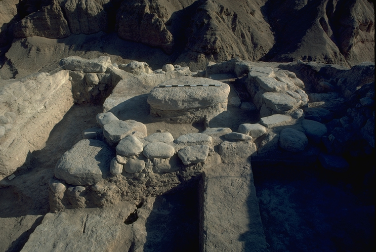
At the beginning of EB III a new sanctuary building was constructed (Field XII) on the foundations of the earlier one, with only slight differences in the orientation of the eastern and western walls. The interior plan, however, differed from the earlier structure. A floor made of brick and marl covered the southern half of the building while an elevated flagstone floor on the northern half was approached by a mudbrick stairway. The doorway to the later building was on the broad wall on the west. To the west of the building a courtyard area, paved with mudbrick and plaster included a semicircular stone altar. Objects found in the court or inside the building included a wooden post with inlaid design, a cylinder seal impression with a possible cultic motif showing a line of figures behind a wall (N. Lapp, 1989) and several fan scrapers. Edge ware analysis of the fan scrapers suggested they were probably used for butchering animals.

On the interior of the town three major phases have been identified, each of which involved fundamental rebuilding. In the earliest phase retaining walls were built against the slopes of the town interior, apparently to prevent erosion. Buttress and terrace walls also were constructed to level off new areas for buildings (Fig. 5). Most of the walls during this phase were built of mudbrick without stone foundations. In Field XIV several walls were leaning at an almost 45 degree angle which may have been caused by earthquake. The middle phase displayed rebuilding following a similar orientation, but in this phase the structures often had stone foundations. Remains of the latest phase suffered the most deterioration but they suggest a pattern of poorly made mudbrick and stone structures towards the end of EB III.
In Field XI the major building begun during the latter part of EB II continues in use throughout several phases of EB III. The last use of this area involved a major rebuilding with the construction of two flanking towers with massive stone and timber foundations, each tower being 4 m. in width. A 3 to 4 m. space between the towers most likely served as a passageway, and thus this structure has been interpreted as a gate. Erosion made it impossible, however, to determine a connection with the defensive system. The evidence in Fields IV and XIII that the west gate was closed off in its latest phase supports the interpretation that the northeast tower functioned as the major gate to the city during the latter part of EB III.
Throughout most of EB III burials took place in rectangular mudbrick funerary buildings constructed in the eastern portion of Cemetery A. Seven of these buildings were excavated by Lapp and two by the EDSP. Doorways were always in one of the long walls and were flanked by large orthostats. A threshold stone led to a single step down into the interior of the building. The smallest building was 2.80 by 4.80 m and the largest 7.50 by l5 m. Three of the buildings were approximately 4.50 by 9 m. and three others were 5.50 by 11.m.. Five of the buildings had cobble stone floors, while others had gravel or loose stones.
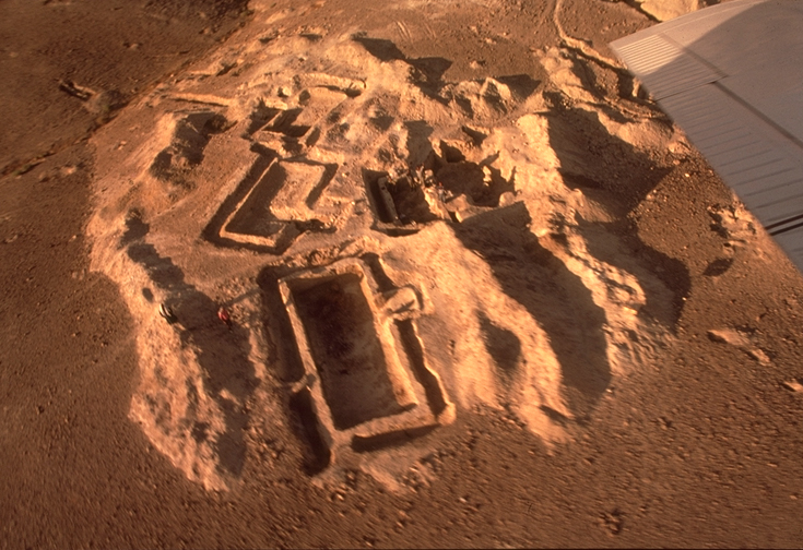
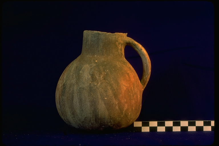
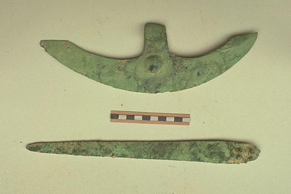
Burials in the funerary buildings were primary with the earlier ones moved against the walls to make room for later burials (however, see Chesson 1999 for alternative argument about secondary burials). Pottery forms included a broad range of platter bowls, small saucers, lamps, pitchers, cups, jugs and juglets, including miniature forms. A complete classification of the forms including comparative volume studies and suggested typological sequences appears in the final report of the Lapp expedition (Schaub and Rast, 1989). It is clear from the range and the duplication of the types that many of the buildings were in use at the same time over a considerably long period. It thus seems likely that the buildings were associated with various social units within the town. Evidence for possible social stratification came from the largest building, Tomb A22, which contained several pieces of gold jewelry (Fig. 6). Typical objects found in the funerary buildings included bronze knives, and crescentic axe heads, slate palettes, wooden combs, numerous cloth examples including finely woven linen, and a wide range of beads and shells used as jewelry.
Four of these buildings had extensive burn areas with remnants of burnt roof beams and fragments of wattle and daub roofing. Although there were a few intrusive later burials associated with late EB III and EB IV pottery, the destruction of the buildings coincides with the end of the main EB III occupation of the walled town.
It is possible to estimate that during EB III the walled town covered approximately 9 acres. Extramural population also extended beyond the walled area on the east and west ends. Space in the town and immediate environs would have been sufficient for a population of 600?1000 individuals. Analysis of water resources and land available for farming during the Early Bronze Age led to the conclusion that these would have more than ample to support a population of this size (Harlan, 1981). The major food crop was probably barley, but flotation has yielded a wide assortment of crops including einkorn, emmer and bread wheat, two?row and six?row barley, grapes, olives, figs, chick pea, lentil, flax, pistachio and almond (McCreery, 1981). The large size of the flax seeds suggests that irrigation was employed. Weaving tools found in the town site, and large amounts of linen cloth found in the burial houses, suggest a local textile industry (Adovasio & Andrews, 1981). Among the faunal remains sheep-goat predominate, but large mammal bones are also represented, including donkey and cow (Finnegan, 1978). A series of game stones with indentations in a three by 10 pattern possibly date to EB III although none have found in a stratified contest (Lee, 1982).
Exchange in the local region is attested by ceramic objects using temper found only in the Numeira area (Schaub, 1987). Among cultural items which reflect foreign contact, several, such as slate pallettes, combs, and possibly one or two cylinder seals have their best parallels in Egypt while the majority, including architectural features, cylinder seal impressions, jewelry, some forms of pottery and a carved bull’s head, show Syrian if not Mesopotamian influence (Rast 1980). Two metal daggers also appeared to be Syrian in style. One of these was made of tin bronze and is thus one of the earliest true bronzes known from ancient Palestine. The other is of relatively pure unalloyed copper. All other copper-based objects analyzed have low levels of arsenic, which may have come from Anatolia but whose use was virtually universal in southwest Asia in the third millennium B.C.(Maddin, Muhly and Stech 1983).
Late EB III-EB IV Settlement. Evidence for the latest use of the Bab edh?Dhra site comes from areas south and east of the town (Fields IX and X), one area within the town (Field XVI), and a small number of tombs.
In Field X, about 150 m. east of the town site ,four phases were distinguished. The earliest included a rectangular mudbrick building with an associated court yard. Many carbonized cereal remains were recovered from the oven areas in the courtyard. Pottery forms of this level represent a phase earlier than the typical rilled-rim bowls, teapots and jars usually associated with EB IVA. The best parallels come from levels designated as late EB III at other Palestinian sites. A thick layer of debris and a fill layer separated the first and second phases. The latter appears to have been limited to a brief time with only one wall fragment surviving. The last two phases, with typical EB IVA pottery forms, had clear habitational surfaces but only fragmentary structural remains, including two long parallel stone foundation walls. To the south of the town site, in Field IX, only isolated oven areas represented the late EB III phase, but a group of rectangular broad-room buildings with stone wall foundations and occupational surfaces included EB IVA materials
On the northern ridge of the town area, overlooking the Wadi Kerak, excavations in Field XVI revealed a similar succession of late EB III and IV habitation. EB III usage included two terrace walls, one of stone and one of mud brick, and two storage pits cut into the natural soils. During EB IV the area was converted into what seems to have been a ceremonial precinct. In the first phase several walls constructed in connection with vertical and horizontal cuts made on the northern slope. The terraces created through this activity were then utilized through three successive rebuilds of the area. The walls and doorways of the various phases all had a smooth plaster facing. The latest phase included a large flat stone, possibly an altar, set on a stone foundation, a mud brick pedestal column with a flat stone surface, and walls enclosing the altar area. Dozens of animal horns around this area, along with the unique architecture and an incense stand indicated that this may have been the EB IV cultic center.
In the cemetery one shaft tomb dated to late EB III, and four with EB IV material, have been excavated. The late EB III tomb, (Tomb D 1),had a stone-lined shaft with the back edge perpendicular to the front edge of the stone foundations of a rectangular building above it. The building itself had no occupational debris. The doorway at the bottom of the shaft led to two large chambers which had been cut into the natural marl, and with a passageway leading to both chambers. The walls had been plastered. One chamber was excavated in l967 and included several articulated skeletons with a small group of pots similar to pottery associated with the latest levels of the funerary buildings. A few examples of the same type of pottery were also found in the latest EB III tombs at Jericho. The second chamber, disturbed after the 1967 season, was cleared in l975. It yielded thirteen skeletons and a bronze dagger.

Two EB IV tombs were excavated under Lapp’s direction in Cemetery A. Both had stone-lined shafts and single large chambers, with partially articulated burials and large groups of EB IV A pottery (Schaub 1973). Two chambers dated to EB IV A were also excavated by the present expedition in 1979. The chambers had been exposed by a recently constructed water trench which partially cut through both chambers and obliterated the evidence of a shaft. Some of the pottery published by Albright (1944) also belongs to this horizon.
Although interpretation of the latest EB occupation at Bab edh-Dhra’ remains problematical, particularly with regard to the critical question of continuity in population with the EB III town dwellers, the settlement pattern of an open village seems clear. The EDSP has established the rather solid conclusion regarding EB IV at Bab edh-Dhra’, that EB IV occupation is mostly absent from the town site, with the exception of the special area in Field XVI, and that most of the occupation seems to have taken place away from the ruined remains of the town.
The lack of evidence within the town site, of course, could be attributed to the millennia-long erosion that has affected the center of the town site. But there are well defined areas that have not suffered from erosion including some where aggradation is the pattern. Within the defense line at the west end of the town there was a 4 m. build-up of silt levels covering the latest EB III habitation and the collapse of the town wall. No EB IV occupation was found in this area. A similar build up took place at the eastern end and the probes in this area did not uncover EB IV levels. In Fields XI, XII and XVIII, located on the highest areas of the town, no evidence of EB IV habitation was found. Yet in Field XVI the series of four EB IV levels associated with the sanctuary were uncovered in a well-preserved state.
The positive evidence for EB IV from Fields IX and X outside the town area and from Field XVI on the northern ridge supports the interpretation that the settlement pattern had reverted to open occupation. Substantial building remains, abundant carbonized cereal remains, and the articulated burials in the tombs suggest permanent occupation although seasonal return by peoples still drawn by cultic and traditional ties to the area cannot be ruled out. It seems likely that the erosional forces that the EB III town dwellers were fighting against in the center of the town and the destruction of the town defenses made the town generally unsuitable for habitation by the EB IV occupants.
Continuity in the populations of EB IV and EB III is a more difficult question. Features common to both horizons such as broad room buildings, the red-slipped pottery, and primary burial all suggest possible continuity. But some major changes in the ceramic typology appear to pose problems for close continuity. The typical high-shouldered, narrow-necked stump-based jars and juglets of classical EB III disappear and are replaced in EB IV by low-profile, wide-mouth, broad-based jars and juglets. This change is deceptive. The narrow necked vessels can be associated with trade during the urban phase. A comparative study of all of the basic tomb forms throughout the Early Bronze Age suggests that the “new” EB IV forms are similar to the basic forms of EB IB and may reflect a return to a simpler life pattern following the breakup of the town and its trading networks (Schaub and Rast, 1989). A series of calibrated C?14 dates from Field X suggest a date of 2200 B. C. for the latest EB IVA phases of occupation (Schaub and Rast, 1989).
BIBLIOGRAPHY
Identification and Exploration: W.F. Albright,AASOR 6 (1926), 58?62. P.W. Lapp, Jerusalem Through the Ages, Jerusalem,1968a, 1*?25*. W.E. Rast and R. T. Schaub, ADAJ XIX (1974), 5?53. W.C.van Hattem, BA 44 (1981), 87?92. W.E. Rast, Glenn Rose Festschrift,1984. W.F. Albright, BASOR 14 (1924), 5?9. A. Mallon, Biblica 5 (1924), 413?55. S. Saller, Liber Annus 15 (1964?65), 137?219. D.W. McCreery, ADAJ XXII (1977?78), 150?162. V. Clark, ADAJ XXVI (1982), 113?119. C. Bennett, Levant 12 (1980),30?39.
Excavations: P.W. Lapp, Archaeology 19 (1966), 104?111; idem, RB 75 (1968b), 86?93; idem, BASOR 189 (1968c), 12?41. W.E. Rast & R.T. Schaub, AASOR 43 (1976), 1?32; idem, AASOR 46 (1979); idem, BASOR 240 (1980), 21?47; idem, BASOR (in press). B. Frohlich & D.J. Ortner, ADAJ XXVI (1982), 249?267. J. Donahue, BASOR 240 (1980), 47?52. M.A. McConaughy, AASOR 46 (1979), 187?190. D.J. Ortner, AASOR 46 (1979), 119?132; idem, Studies in the History and Archaeology of Jordan, I (1982), 93?95. R. T. Schaub, Studies in the History and Archaeology of Jordan, I (1982), 67?76. P.W. Lapp, Near Eastern Archaeology in the Twentieth Century, Garden City, N.Y.,(1970), 101?132. J.A. Callaway, Early Bronze Age Sanctuary at Ai, London (1972). J.R. Harlan, AASOR 46 (1979), 155?164. D.W. McCreery, AASOR 46 (1979), 165?171. J.M. Adovasio & R.L. Andrews, AASOR 46 (1979), 181?186. M. Finnegan, AASOR 46 (1979), 177?180. J.R. Lee, Levant XIV (1982), 171?174. W. E. Rast, Scripta Mediterranea. I. (1980). 5?20. J. Maddin, R. Muhly & T. Stech (1983),in press. W.F. Albright & J.L. Kelso, BASOR 95 (1944), 3?13.